
- Hikes in Arizona
- White Mountains and Eastern Arizona
- Bear Mountain - Blue range
Bear Mountain - Blue range
Location
To the Trailhead: From the Phoenix area, take HWY-60 east all the way to Springerville. From Springerville, take HYW-180/HWY-191 to Alpine. In Alpine, take HWY-180 East about 2 miles out of town and turn right (South) onto the signed Blue River Road (Also FR281). The Blue River road starts out as paved, but turns to a well maintained dirt road after a few miles. The road is in good shape, but there is one crossing of the Blue River that could be a problem for passenger cars, depending on the flow at the time. It is safest to use a high clearance vehicle for this drive. After 27 miles, you will see the signed trailhead (Blue Camp, Lanphier Trail) on the left and a small parking area.
Hike details
Season
- June
- July
- August
- January
- February
- December
Solitude
Difficulty
Permits
Hike and Backpack on Bear mountain in the Blue range primitive area in Arizona.
Due to its remote location, the mountains of Eastern Arizona remain pretty secluded. One of the best areas we have found to enjoy this seclusion is in the Blue Range primitive area. As of 2007, the Blue Range of mountains is the last remaining primitive area on National Forest lands. Similar rules apply to this area as to a wilderness, namely no motorized vehicles or mountain bikes.
A note about camping. We drove up to the trailhead from the Phoenix area on the Friday before a Memorial Day weekend. We had planned on dry camping at the trailhead, but the trailhead is wedged between private property and the Blue Camp administrative area. Scattered cow pies and ants prevent an enjoyable camping experience. We backtracked to the Upper Blue Spring camping area (which you pass while driving along FR281 - Blue River road). The camping area is small and has no treated water, however we had no trouble finding one of the few camping spots and no one else joined us in this camping area. The Blue river runs nearby if water is needed (be sure to treat it). We would recommend camping here instead of at the trailhead for comfort. If you don't want to camp in an organized camping area, there are places along FR281 to camp, but there is also much private property to stay away from. Please be respectful of the private ranches in this area and observe the 'no trespassing signs'.
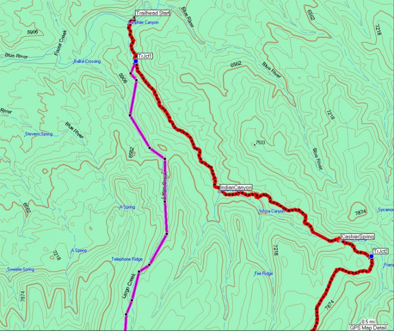
At the trailhead, be sure to sign the guest register. While there are two trails here, we are interested in the Lanphier trail. The Lanphier trail skirts the edge of a private ranch and walks for a short distance down a dirt road before crossing the Blue River. We were able to keep our feet dry on the hike in, but on the hike out, rains had increased the river flow and we had to wade just a bit. After crossing the river look for a cow corral and a sign affixed to it on the left that marks the trail.
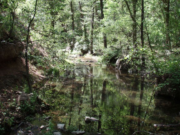
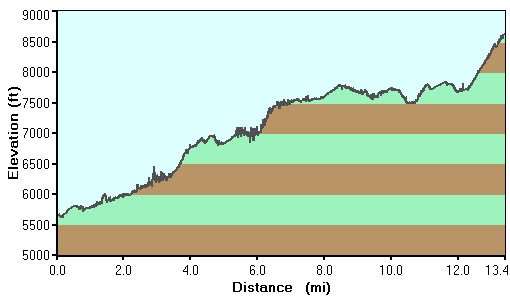
From this point, you will be following the well worn Lanphier trail up Lanphier canyon. About 0.5 miles from the start, you will see a signed trail junction (TrJct1 on map) to the Largo Trail heading off to the right. This will be our return path, so stay left (Lanphier trail) here. There is a lack of shade at the start as the trail follows the creek. The more elevation gained, the more shade you will enjoy from walnut trees, ash trees, and oak trees. Interestingly, there are also grape vines and strawberry vines in this area. We were hiking too early in the season to eat the wild grapes and strawberries, but they were growing while we hiked through. There are a few creek crossings in this section, but nothing that will get your feet wet.
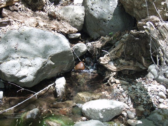
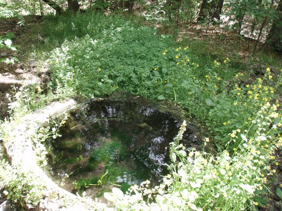
2.7 miles from the trailhead, you will cross Indian creek for the final time. Depending on what time of year you are hiking and recent rains, this may be the last place for you to get water for your evening camp. We were lucky and observed water still present in Lanphier creek so we continued our hike up to Cashier spring (about 4.7 miles from the trailhead). There was water in Cashier spring and we filled up here for our use in the evening.
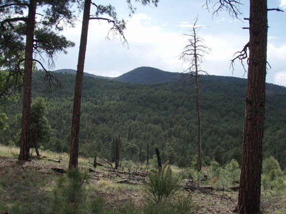
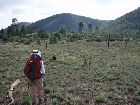
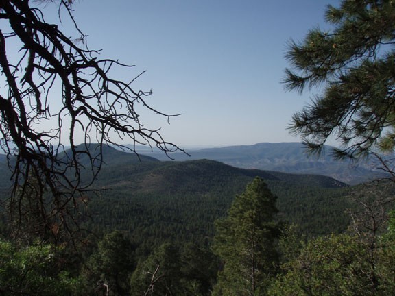
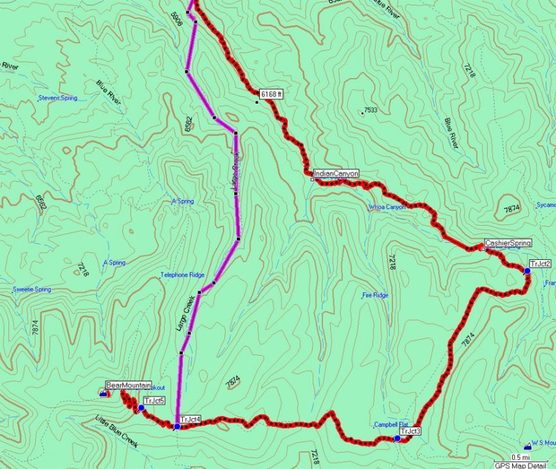
From Cashier spring, the trail climbs out of Lanphier canyon and onto the rim. At 5.1 miles, you reach a signed trail junction (TrJct2 on map) with the Cow Flat trail. Bear right here and hike along the relatively flat pine forest. From the trail junction it is 2.2 miles to the next trail junction (TrJct3 on map) with the WS mountain trail (also signed). Follow the signs to "Bear Mountain" here. While you hike along this section, keep an eye out for any nice campsites for the evening. There are several meadows you will cross that open up some views of the surrounding area. To the East, you can see into the wilds of New Mexico. You will need to use your route finding skills in this section, as the pine needles and oak leaves can cover the trail so completely, it is easy to lose the trail. If you do lose the trail, look on the trees where small cuts have been chopped to help mark the trail. If there are no cuts on the trees to be found, try looking for rock cairns. Eventually, we settled on a campsite at the foot of Bear mountain, near the signed junction (TrJct5 on map) of the WS mountain trail and the Largo Trail. This junction is about 2.8 miles from the WS mountain/Cow Flat trail junction.
Hopefully you are enjoying the solitude this area has to offer. During our hike, we saw wild turkeys, a fox, elk, and deer. There are also black bear (we observed plenty of bear tracks and scat) and Mexican gray wolves in this area. Make sure that all food is hung from trees to prevent any problems with animals eating it (or being attracted by it). The wild turkeys woke us up in the morning, but they didn't get any of our food!
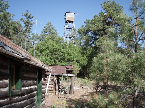
The next day, we woke up and warmed up our sore muscles on a quick hike to the top of Bear mountain. It is about 1 mile and 1000 ft of elevation gain from the Largo trail/WS mountain trail junction. Primarily you will be shaded by pine trees, but once in a while, there are breaks in the trees where you can enjoy some views of the surrounding area. The top of Bear mountain is forested, so the views are diminished. There is a fire lookout tower here and a few buildings (including an outhouse) for the forest service personnel manning the tower. You can climb up the tower (if open) to get clear views of the area.
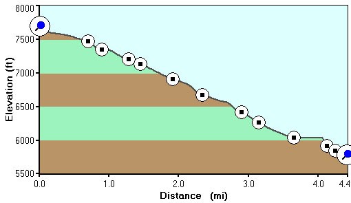
There are a few trails that branch off here, so make sure you take the same one back to the Largo trail/WS trail that you came from (we didn't and got a bit lost for a while). From the Largo trail/WS trail junction, head down the fern covered forest towards Largo creek. The final 4.4 miles follows along Largo creek (which had some water in it when we hiked this, but is normally dry). You will pass two reliable springs for water: Maple spring and Dutch oven spring. Dutch oven spring is particularly scenic. This section of the trail descends steadily, is well shaded, and is easy to follow. At the end of the Largo trail, you will exit the creek by going over a small saddle and dropping back into Lanphier canyon. The trail will then rejoin the Lanphier trail and a short 0.5 miles will get you back to the trailhead.
