
- Hikes in Arizona
- Grand Canyon / Marble Canyon
- South Canyon
South Canyon
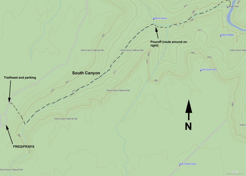
Location
From Page, Arizona, take HWY-89 south to the junction of HWY-89 and HWY-89A. Turn right here and take HWY-89A North-west, across the Colorado river and to the turn off for FR-8910 (about 35 miles of driving, between mile markers 559 and 560). The turn-off for FR-8910 is well signed as "House Rock Buffalo Ranch Road". This is a well graded dirt road, easily passable with a high clearance 2-WD vehicle. After about 19 miles, turn left at FR632, which is well signed. This dirt road is more rocky and has some ruts, but is still easily traveled with a high clearance 2-WD vehicle. After traveling about 2 miles (and passing along a dirt runway... stay to the right!), you will reach a well signed junction. To the left is the headquarters for the wilderness area, to the right is the South Canyon trail junction. Turn right and drive the final 1.2 miles to the trailhead. There is a gate just before reaching the trailhead, please close it behind you. Keep an eye out for wildlife during this drive, as we were surprised early in the morning by a deer tearing across the road at eight in the morning... better than coffee to get your adrenalin pumping! This is also supposed to be a good area to spot a California Condor.
During or just after rains, the nice dirt road described above can be completely impassable to any vehicles. Best to stay away from this area if rain is in the forecast.
Hike details
Season
- March
- April
- September
- October
- June
- July
- August
Solitude
Difficulty
Permits
SPECIAL CONSIDERATIONS FOR WINTER AND SUMMER TIMES:
, For Winter Hiking: Access may be blocked to FR-8190 during the winter in the event of snows or winter rains.
, For Spring/Fall Hiking: Get an early start and don't hike during the heat of the day. Remember that the bottom of the canyon will be hotter than the top. It is not recommended to take this hike past the beginning of May or earlier end of September.
Hike and Backpack down South Canyon in Grand Canyon national park, Arizona.
South Canyon has an interesting history. One of the earliest groups to navigate the inner gorge of the Grand Canyon was lead by Robert Brewer Stanton (1889), who was representing a railroad company with plans to build a railroad through the canyon. Their expedition ran into great difficulties and they decided to hike out of the canyon here. The cave they stashed their gear in (Stanton's Cave) was later found to contain wood figurines dating back 4000 years. The cave has bars across it to protect the archeological value of the cave, but you can look inside.
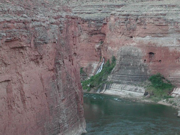
Also of interest here is Vaseys Paradise, which is a set of natural springs flowing from the canyon walls into the Colorado. The spring is easily seen from the beach and is about 0.5 miles downriver to walk to. Watch out for the poision ivy at the spring!
Before starting the hike, be sure to look around and enjoy the remoteness of this location.
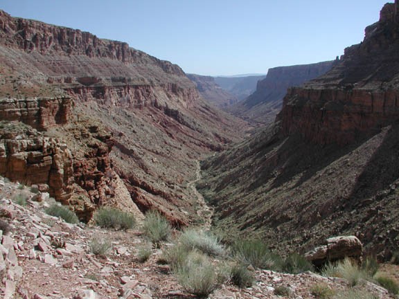
The start of the trail provides the best views of the entirety of South Canyon. The drop into the canyon floor is steep (800 ft in 0.6 miles) and the footing can be uncertain at times. In order to navigate this steep but impressive section of trail, keep your eye out for the cairns that mark the route. There may be one or two spots where you will feel more comfortable taking off your pack to down climb here.
After reaching the bottom of the canyon, the route flattens out and you spend most of your time walking around and over boulders. Keep your eyes out for the elusive trail cairns that mark some flat bypasses to the rock-hopping. There are a few falls that need to be navigated around, but there are well marked hiker routes around these falls. There are four falls in all, two before reaching the confluence of Bedrock canyon (walk around is to the right while facing down canyon), one before the confluence of Bedrock canyon (again, walk around to the right), and the final unmistakable walk around of the narrows at the mouth of South Canyon (long walk around to the left). This final walk around travels up and down (cairns lead the way) before reaching a wonderful view of the Colorado River as it winds through Marble Canyon. You can clearly see Vaseys Paridise and the beach from here.
The final 300 ft decent to the beach provides access to all the rewards of this hike. Keep your eyes on the canyon wall to your right as you descend, as there are some Native American ruins in the caves here to explore. Keep looking for those cairns during this section to guide you.
There are several places to camp here, with a smaller beach on the left and the larger beach on the right. Camping is primitive here, so bury waste in 6' cat holes and urinate directly into the river. Also carry out all your trash. Downstream are the trails to Stanton's Cave and Vaseys Paridise. About 2 miles hike down canyon leads you to a location where you can see the Redwall Cavern, a very large rock amphitheater on the opposite side of the river.
The return route is the same as described above.
