
- Hikes in Arizona
- Superstition and Mazatzal Wilderness
- Bluff Spring Loop
Bluff Spring Loop
Location
To get to the trailhead: From the Phoenix area, take US-60 East, leaving the city limits. After leaving Apache Junction, continue about 8.5 miles, turning left onto Peralta Road (FR 77). THis turn is signed as the turn-off for Peralta Trail. After starting out as a paved road, this quickly turns into a maintained dirt road. The trailhead and parking appears after 7 miles on this road. The trailhead is well marked and there is a toilet at the trailhead, but no water.
Hike details
Season
- January
- February
- March
- October
- November
- December
Solitude
Difficulty
Permits
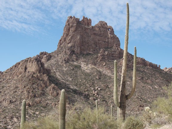
hike the Bluff Spring trail around Miners Needle in the Superstition Wilderness, Arizona.
The Superstition Wilderness is a relatively short drive from the Phoenix area, but affords a multitude of remote desert wilderness hiking. This loop trail introduces the hiker to some of the varied scenery and hiking opportunities in the area.
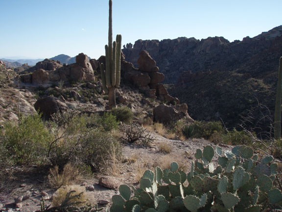
From the Peralta trailhead, take the well defined Dutchman's Trail generally East towards the prominent landmark Miners Needle. This part of the hike is relatively flat and features wide views of the Saguaro spotted desert. After about 2.3 miles of hiking, you will pass the junction of the Coffee Flat trail and start a climb to a saddle behind the Miners needle. From this direction, it is easy to see why the formation is called a 'needle' as there is a clearly recognized hole through the rock. After about 800 ft of climbing, you will reach a saddle with Miners needle behind you and Bluff Mountain to your left with some big picture views of the Superstition Wilderness.
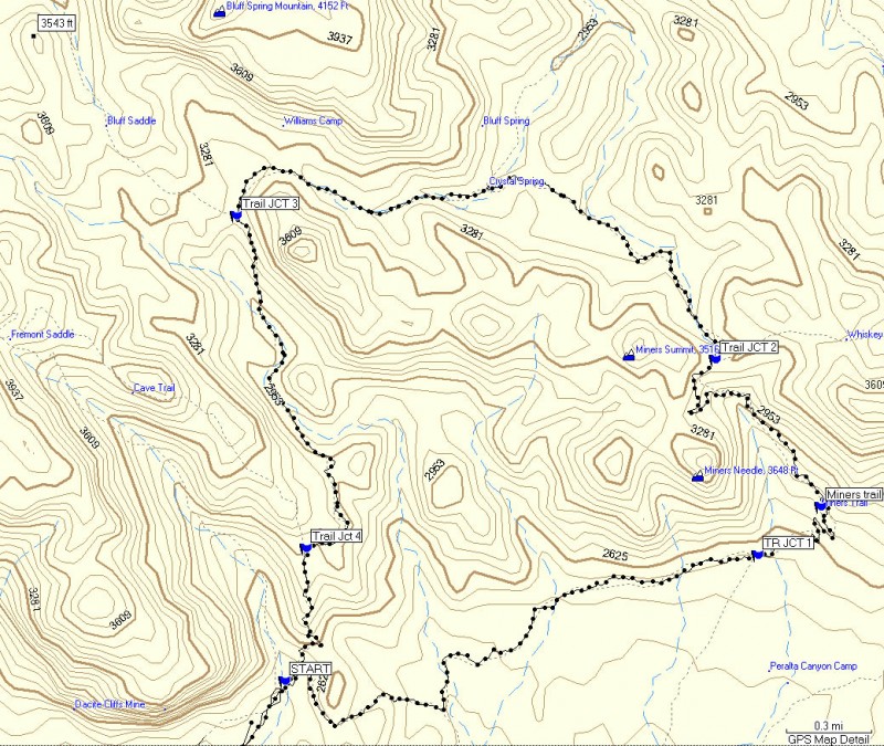
Map Waypoints:
Start: Peralta Trailhead
Trail Jct 1: Stay Left here at the junction for the Coffee Flat Trail
Trail Jct 2: Stay Left here at the trail junction for Whiskey Spring Trail
Trail Jct 3: Stay left here at the trail junction for the Terrapin Trail
Trail Jct 4: Stay left here.
After 4.8 miles of hiking on the Dutchman trail, you will now switch over to the Bluff Spring trail by going left at the trail junction. This section of the trail tends to be more overgrown and can be tricky to follow as it crosses in and out of desert washes. Keep a close eye out for Cairns to stay on trail. The nice part is the major trail junctions are all well signed.
The trail starts climbing again to the junction of Terrapin trail, which is reached after about 5.9 miles of hiking. This section of the hike features dramatic views of Peralta Canyon and Weavers Needle. The final few miles heads South along a ridge line, with Peralta Canyon on your right and an unnamed bluff on your left before the 800 ft drop back to your waiting car.
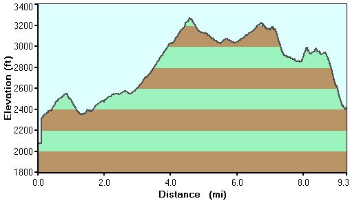
Please note, the mileage and elevation gain we noted on our GPS differs significantly from Bruce Grubbs Hiking Arizona's Superstition and Mazatzal Country book. This area used to be a fee area, but is now free. How long that will last is anybody's guess.
