
- Hikes in Arizona
- Grand Canyon / Marble Canyon
- Paria River Canyon (White House to Lees Ferry)
Paria River Canyon (White House to Lees Ferry)

Location
WHITE HOUSE TRAILHEAD: From Flagstaff, take US Highway 89 toward Page, AZ. Take HWY 89 west out of Page, AZ for 30 miles. Turn left at the sign for White House trailhead (between mileposts 20 and 21). The trailhead is 2 more miles on a well graded dirt road.
WARNING: Make sure you put the permit sticker in your car windshield before you head out... the fine is steep if you don't! Also carry your permit with you, as we met some forest service folks who were checking permits deep in the canyon.
LEES FERRY TRAILHEAD: From Flagstaff, take US Highway 89 toward Page, AZ. Take HWY 89A at Bitter Springs and cross the Colorado River at Navajo bridge. Soon after, turn right at the sign for Lees Ferry (before you get to Marble Canyon Lodge). After about 5 miles on this paved road you can park at the 14 day long term parking lot.
Hike details
Season
- April
- May
- September
- October
- January
- February
- June
- July
- August
- December
Solitude
Difficulty
Sorry, grandma can't come. You probably want to leave the kids at home too if you're making this a multi-day hike. A day hike with kids partially into the canyon would be OK.
This is a rare and beautiful place, possibly without peer in the world. There will be many river crossings, so wear appropriate footwear. This is one of those hikes you will be talking about for months afterwards. Averaging 12 miles a day with a full backpack makes this hike Strenuous.
Permits
WARNING: Make sure you put the permit sticker in your car windshield before you head out... the fine is steep if you don't!
Hike and backpack along the Paria River, Arizona.
Everyone once in a while I read books and magazines that list the best hikes in North America. It is a rare event when I see one of these lists that does not include this hike. After spending three days in this amazing place, I now understand.
Due to job demands, we decided to spend three days and two nights to hike through the Paria river canyon from the White house trailhead to Lees Ferry. We first made reservations with the BLM (435) 688-3200 or on the web at www.blm.gov/az/st/en/arolrsmain.html. This is a critical step as overuse has hurt this area in the past and there are stiff fines for not procuring a permit before hiking. Also, try to get a copy of the "Hikers Guide to Paria Canyon" which is $8 from the BLM. This is well worth the investment as it gives a very accurate map of the length of the canyon and is invaluable to navigation. We dropped a car at the Lees Ferry Trailhead and contracted with one of the local concessionaires to shuttle us from the Lees Ferry Trailhead to the White House trailhead.
DISCLAIMER: We had nearly perfect conditions for this hike. The water level in the Paria river was pretty low and the temperature was moderate. You need to be prepared for deeper water and hotter (or cooler) temperatures depending on the time of year and the weather. I know people who have taken this hike in the early spring and the multiple river crossings caused frostbite in their feet. Use good judgment and prepare accordingly.
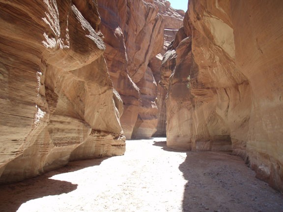
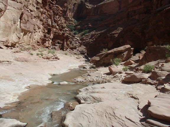
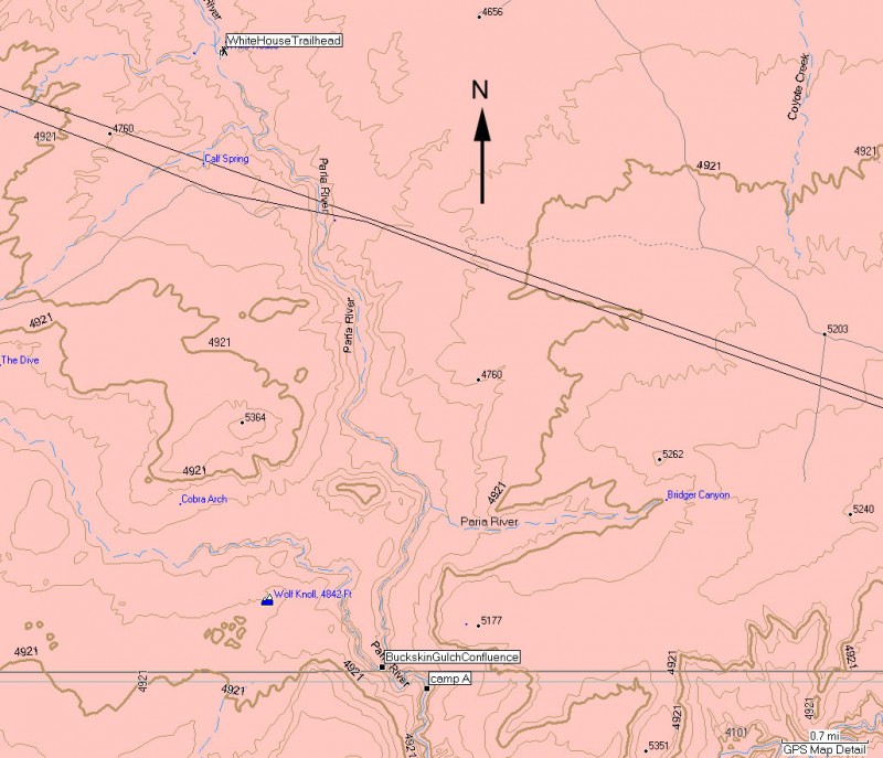
Starting from the White House trailhead, the Paria river may be just a trickle or appear as a desert wash. Rest assured it will get stronger as the hike goes on. When we took this hike in late May, Arizona was having a typical dry month, so the river was dry here. After about 4 miles hiking along the sandy, dry wash you'll hit the start of the narrows. This is where the fun begins.
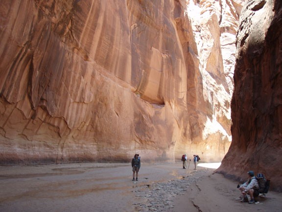
This section shows off the tightest narrows of the trip. Seven and a half miles from the trailhead you will reach theBuckskin Gulch confluence entering from your right. Stay left at the confluence to stay in the Paria river and continue enjoying the narrows. From here, it is likely the river will start to appear if it hasn't already. The river will now stay with you for the duration of the hike, remaining shallow and easy to cross. You'll pass a few nice campsites and springs before reaching a meander (also known as an oxbow) on your left. This is a section of the canyon where the water has cut itself off so there is a dry fork that bends back to the river.
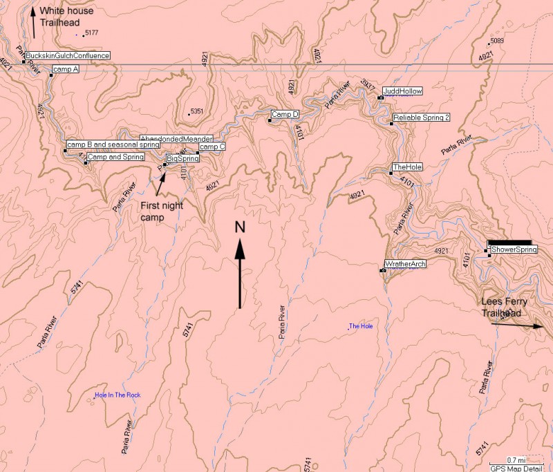
We camped at Big spring (mile 12.5) on the evening of the first day of hiking. Big spring has a number of nice campsites nearby. Unfortunately, other hikers tend to think the same way, so the seclusion will be good here, but not great. The benefit is a short walk to refresh your water supply. The park service does not recommend drinking the Paria river water due to the potential of pesticides in the river. They also recommend treating the spring water, which may be good advice because a friend of mine picked up a case of Guardia in this canyon. We drank directly from Big Spring but filtered the water we took from Shower Spring and Last Chance Spring.
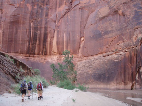
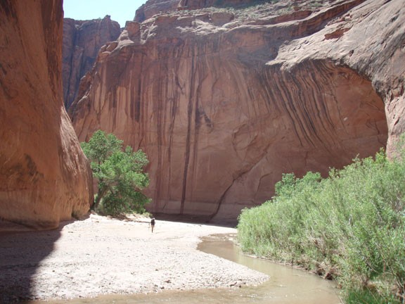
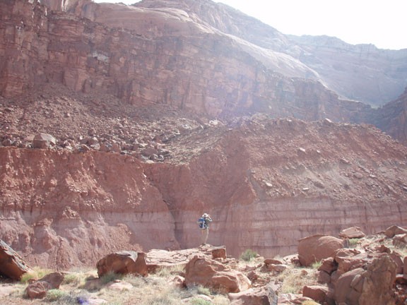
The next day brings a wider canyon, but significantly higher and more impressive cliff walls. This section of the hike is the one that will burn into your memory for long after you leave the canyon. 500 ft walls and a peaceful river are your constant companions here.
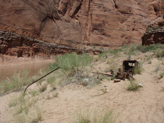
Further on (canyon left) are the remains of a 1949 attempt to pump water from the Paria river to the canyon wall above (mile 17.5). At mile 19 is a side canyon called 'The hole'. during rainy times, the water drops into this canyon with such force you can clearly see the unique effects on the rock. If you've got the time and energy, take the side trip to Wrather Arch, which is about 1 mile up a side canyon to your right at mile 20.5. This is the sixth largest natural arch in the world.
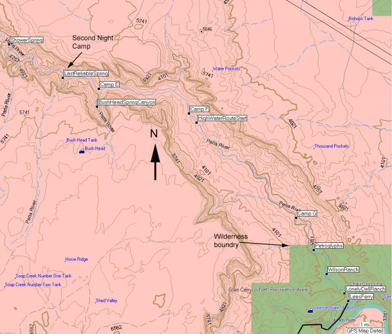
The canyon begins to change after this point. The walls are no longer as sheer and the canyon continues to open up. The river also becomes stronger, although still easy to cross. Our second night we camped near the last reliable spring. We had incredible luck, as we didn't have to share the camp or spring with anyone.
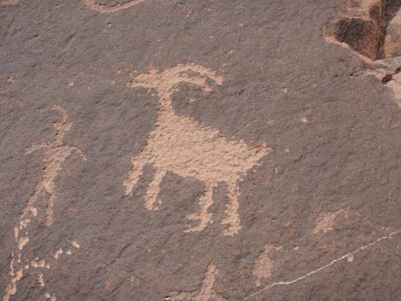
On the third day of hiking the canyon goes through it's final metamorphosis, opening up into a significant desert drainage. Between miles 27 and 28, there will be a high water route on river right. This will save you significant time, as you can walk along the flat bench above the river. In hot weather, this is a tough slog. Keep an eye out for cairns to stay on the unmaintained trail. Also, there are several sections of petroglyphs during this section of hike, all on river left.
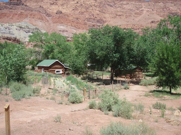
You will know you are nearing the end of the hike when you start to see the ruins of Wilson Ranch at mile 33.5. The wilderness boundary is a mere 2 miles away from here. You may meet day hikers that are hiking up from Lees Ferry from the Lonely Dell Ranch. This ranch has been well preserved and is worth exploring... a fitting end to an epic hike.
Milestones:
Note: There are many more potential camps and springs than the ones listed below. The majority of the springs are found on river right. River right and river left directions assume you are facing down river.
miles landmark
2.5 Power lines cross over the canyon
4.0 The narrows begin
7.3 Confluence with Buckskin Gulch
7.5 Camp
9.4 Camp and spring (river right)
10 Spring (river right)
11.3 Abandoned Meander (oxbow)
12.2 Big Spring (river right) and camps (river left)
12.8 Camp
14.7 Camp
17.4 Judd Hollow Pump (river left)
18.4 Spring (river right) and camp (river right just past the spring)
19.2 'The hole' (river right) and camp (river left)
20.5 Camp (river left) and mouth of canyon that leads to Wrather Arch (river right)
22 Shower spring (river left) and camp (river right)
25.3 Camp (river right) and last reliable spring (river left)
26.5 Camp (river right) at mouth of Bush head canyon. There is also a spring if you hike about 0.5 miles up the canyon.
28.0 Camp (river right) and start of high water route (river right)
30.3 Camp (river right)
31.5 Petroglyphs
33.5 Wilson Ranch
37.3 Trail register
37.6 Lonely Dell Ranch
38.4 Lees Ferry long term parking area
