
- Hikes in Arizona
- Grand Canyon / Marble Canyon
- Rainbow Bridge via Cliff Canyon
Rainbow Bridge via Cliff Canyon
Location
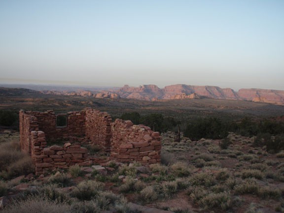
From Flagstaff, take US Highway 89 toward Page, AZ. From Page, it's best to arrange a shuttle from Antelope Canyon Tours (www.antelopeslotcanyon.com). The shuttle is about $75 per person. The shuttle will take you to the ruins of Rainbow Bridge Lodge, about 2 hours drive from Page on some tricky backroads.
There are two ways to get to Rainbow Bridge. The easy way is to rent a boat and boat up Lake Powell to mile marker 50. Boat up the canyon on your right and stop at the dock there. Then hike the mile to Rainbow Bridge. Now there is a much longer and more interesting way to get to Rainbow Bridge. In the times before Glen Canyon Dam, the only way to get to Rainbow Bridge was a long hike from the Navajo reservation. This route is only for the adventurous and athletic, but your efforts are rewarded by the varied views and impressive canyons you will pass through on your way to Rainbow Bridge.
However, be warned that the logistics for this hike are not trivial. First, you need to get hiking permits from the Navajo nation. To arrange this, contact
Lake Powell Navajo Tribal Park office
PO Box 4803
Page, AZ 86040
(928)698-2808
www.navajonationparks.org/htm/antelopecanyon.htm
Cost is $5 per person per day. Contact: Effie Yazzie, Park Manager
Second, you need to arrange an automobile shuttle to take you from Page, Arizona to the trailhead start at the ruins of the Rainbow Bridge Lodge. This is about a 2 hour drive that can be arranged through Chief Tsosie (www.antelopeslotcanyon.com). An early start is recommended. Third, make sure you have a friend of yours meet you at Rainbow Bridge at the end of your hike with a boat (and preferably a cold beer).
Hike details
Season
- March
- April
- October
- June
- July
- August
Solitude
Difficulty
Permits
Lake Powell Navajo Tribal Park office
PO Box 4803
Page, AZ 86040
(928)698-2808
www.navajonationparks.org/htm/antelopecanyon.htm
Cost is $5 per person per day. Contact: Effie Yazzie, Park Manager
Second, you need to arrange an automobile shuttle to take you from Page, Arizona to the trailhead start at the ruins of the Rainbow Bridge Lodge. This is about a 2 hour drive that can be arranged through Chief Tsosie (www.antelopeslotcanyon.com). An early start is recommended. Third, make sure you have a friend of yours meet you at Rainbow Bridge at the end of your hike with a boat (and preferably a cold beer).
Hike to Rainbow bridge via Cliff Canyon, Arizona
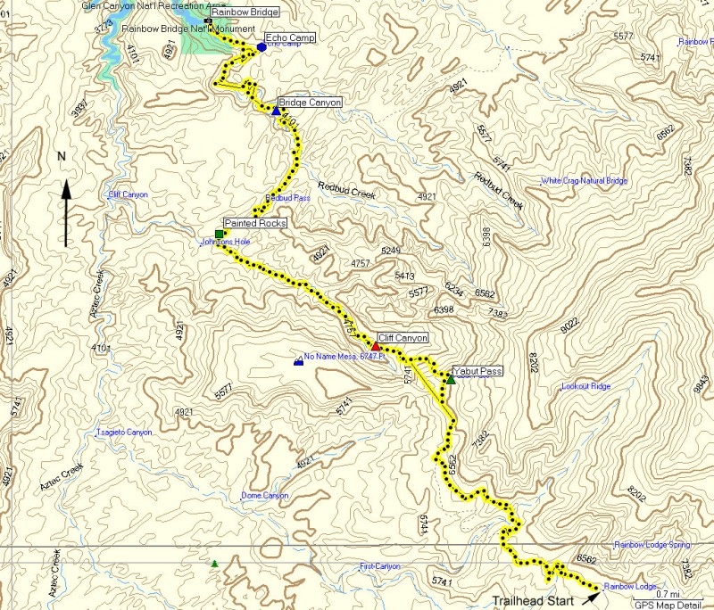
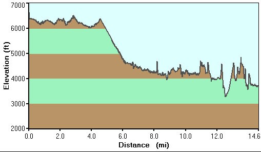
There are actually two routes to hike to Rainbow Bridge. This describes the Southern trail that starts at the ruins of Rainbow Bridge Lodge. From the scenic ruins, follow the road (East) as it narrows into a trail. Watch for the plentiful cairns along the entire length of this trip in order to stay on trail. The trail dives in and out of canyons, displaying wide open views of the stark high desert landscape around. There are multiple trails in this area, so keep an eye on your map to make sure you're headed towards Yabut pass.
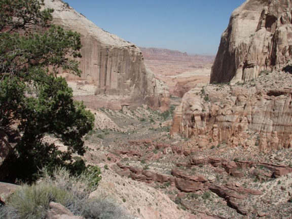
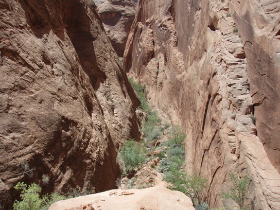
After about 4.5 miles, the trail completes a climb to Yabut pass. After enjoying the high views of Cliff Canyon, you'll begin the descent down to the canyon floor. As you walk along Cliff Canyon, you'll notice a change in vegetation. Water will eventually surface in Cliff Canyon, which nourishes the more lush plants in this canyon. There is some bushwhacking in this section, but nothing too serious. Again, watch for the cairns to stay on the easiest route.
The next landmark is painted rocks, which marks the turn to the North East and Redbud pass. Before heading to Redbud pass, take the time to study the North wall here for some well preserved petroglyphs. There is also the remnants of what appears to be an old corral. Redbud pass narrows significantly, even ending in a climb into Redbud Canyon. There is some scrambling needed here.
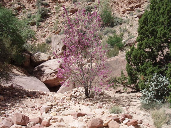
Redbud canyon is very similar to Cliff Canyon. Water is present in this canyon as well and the trail here heads back towards the North West as you get closer to Bridge Canyon. At the intersection to Bridge Canyon, make sure you don't zone out on the trail and miss the turn. If you are headed East, you've gone too far.
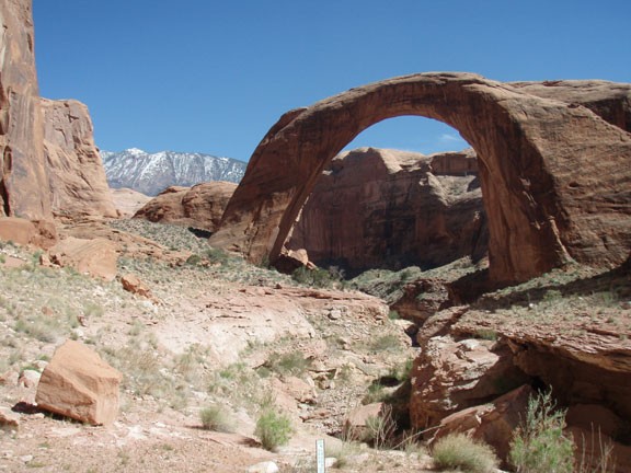
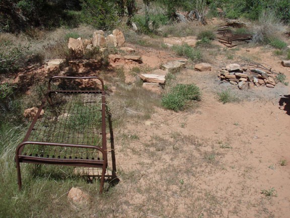
From Bridge canyon it is a short walk to Echo Camp. There are some ruins here from a camp that used to service tourists hiking along this very same trail. From this point, you can start to see glimpses of Rainbow Bridge in the distance.
Rainbow Bridge itself is a magnificent way to end such an epic hike. Enjoy the rewards of your effort, then hike the remaining mile to the boat dock and your shuttle.
